Month: May 2024
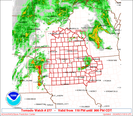
SPC Tornado Watch 280
WW 280 TORNADO IL MO 212255Z – 220500Z 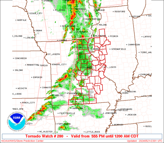
 URGENT - IMMEDIATE BROADCAST REQUESTED
Tornado Watch Number 280
NWS Storm Prediction Center Norman OK
555 PM CDT Tue May 21 2024 The NWS Storm Prediction Center has issued a * Tornado Watch for portions of West central Illinois Eastern into south central Missouri * Effective this Tuesday afternoon from 555 PM until Midnight CDT. * Primary threats include... A few tornadoes likely with a couple intense tornadoes possible Scattered damaging winds likely with isolated significant gusts to 75 mph possible Scattered large hail likely with isolated very large hail events to 2 inches in diameter possible SUMMARY...Scattered supercells and short line segments will remain
possible through late evening in a broken band spreading eastward
across Missouri toward west central Illinois. The more intense
storms will be capable of producing a few tornadoes (one or two of
which could be strong), large hail of 1-2 inches in diameter, and
damaging gusts of 60-75 mph. The tornado watch area is approximately along and 60 statute miles
east and west of a line from 50 miles north of Quincy IL to 25 miles
west southwest of West Plains MO. For a complete depiction of the
watch see the associated watch outline update (WOUS64 KWNS WOU0). PRECAUTIONARY/PREPAREDNESS ACTIONS... REMEMBER...A Tornado Watch means conditions are favorable for
tornadoes and severe thunderstorms in and close to the watch
area. Persons in these areas should be on the lookout for
threatening weather conditions and listen for later statements
and possible warnings. && OTHER WATCH INFORMATION...CONTINUE...WW 277...WW 278...WW 279... AVIATION...Tornadoes and a few severe thunderstorms with hail
surface and aloft to 2 inches. Extreme turbulence and surface wind
gusts to 65 knots. A few cumulonimbi with maximum tops to 500. Mean
storm motion vector 25035. ...Thompson
Watch: Tornadoes tear down wind turbine, cause extensive damage in Iowa

Multiple tornadoes caused extensive damage in Iowa on Tuesday during a severe weather outbreak that storm trackers across the region captured live on video.
SPC Tornado Watch 279
WW 279 TORNADO WI 212100Z – 220500Z 
 URGENT - IMMEDIATE BROADCAST REQUESTED
Tornado Watch Number 279
NWS Storm Prediction Center Norman OK
400 PM CDT Tue May 21 2024 The NWS Storm Prediction Center has issued a * Tornado Watch for portions of Southern Wisconsin * Effective this Tuesday afternoon from 400 PM until Midnight CDT. * Primary threats include... A few tornadoes and a couple intense tornadoes possible Scattered damaging winds likely with isolated significant gusts to 75 mph possible Scattered large hail and isolated very large hail events to 3 inches in diameter possible SUMMARY...Initially, a relatively isolated severe risk will exist
across southern Wisconsin near a warm front, but more numerous
storms with a widespread severe risk are likely to move into the
region this evening. The tornado watch area is approximately along and 35 statute miles
north and south of a line from 15 miles southwest of Lonerock WI to
55 miles east of Madison WI. For a complete depiction of the watch
see the associated watch outline update (WOUS64 KWNS WOU9). PRECAUTIONARY/PREPAREDNESS ACTIONS... REMEMBER...A Tornado Watch means conditions are favorable for
tornadoes and severe thunderstorms in and close to the watch
area. Persons in these areas should be on the lookout for
threatening weather conditions and listen for later statements
and possible warnings. && OTHER WATCH INFORMATION...CONTINUE...WW 276...WW 277...WW 278... AVIATION...Tornadoes and a few severe thunderstorms with hail
surface and aloft to 3 inches. Extreme turbulence and surface wind
gusts to 65 knots. A few cumulonimbi with maximum tops to 500. Mean
storm motion vector 23035. ...Guyer
SPC Tornado Watch 278
WW 278 TORNADO AR KS MO OK 211940Z – 220300Z 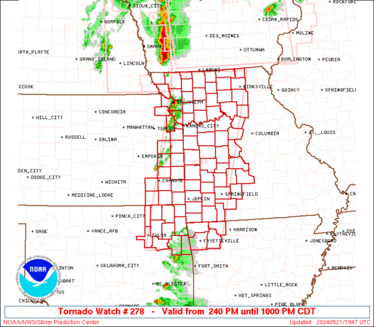
 URGENT - IMMEDIATE BROADCAST REQUESTED
Tornado Watch Number 278
NWS Storm Prediction Center Norman OK
240 PM CDT Tue May 21 2024 The NWS Storm Prediction Center has issued a * Tornado Watch for portions of Northwest Arkansas Eastern Kansas Western and Central Missouri Northeast Oklahoma * Effective this Tuesday afternoon and evening from 240 PM until 1000 PM CDT. * Primary threats include... A few tornadoes likely with a couple intense tornadoes possible Scattered large hail and isolated very large hail events to 3.5 inches in diameter likely Scattered damaging winds likely with isolated significant gusts to 75 mph possible SUMMARY...Severe storms are expected to rapidly develop this
afternoon, initially across far eastern Kansas and western Missouri,
including the Kansas City Metro vicinity, with development a bit
later into northeast Oklahoma and northwest Arkansas. The tornado watch area is approximately along and 70 statute miles
east and west of a line from 50 miles north of Chillicothe MO to 35
miles west southwest of Fayetteville AR. For a complete depiction of
the watch see the associated watch outline update (WOUS64 KWNS
WOU8). PRECAUTIONARY/PREPAREDNESS ACTIONS... REMEMBER...A Tornado Watch means conditions are favorable for
tornadoes and severe thunderstorms in and close to the watch
area. Persons in these areas should be on the lookout for
threatening weather conditions and listen for later statements
and possible warnings. && OTHER WATCH INFORMATION...CONTINUE...WW 276...WW 277... AVIATION...Tornadoes and a few severe thunderstorms with hail
surface and aloft to 3.5 inches. Extreme turbulence and surface wind
gusts to 65 knots. A few cumulonimbi with maximum tops to 500. Mean
storm motion vector 23035. ...Guyer
ð´ LIVE CHASE – Iowa Moderate Risk Coverage, Possible Tornado Outbreak (May 21, 2024) {S}
 {S}")
Join this channel to get access to perks: https://www.youtube.com/channel/UCNPvoDpoOWevcdTHr8GyTyA/join Our chaser Stephen Jones is chasing severe storms capable of strong tornadoes, extreme winds, and large hail in Iowa (May 21, 2024) #IRL #Tornado #StormChasers NOT for rebroadcast or embedding. Email us at contact@texasstormchasers.com for licensing inquiries. Check out our LIVE STREAM: https://texasweather.video/ Our FREE WEATHER […]
Female sea otters particularly adept at using tools to find food, study shows

A new study finds that sea otters off California's coast adapt by using tools to find new food sources and prevent injuries.