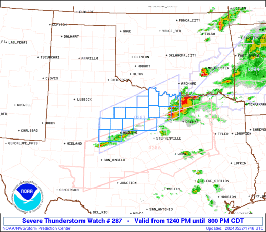
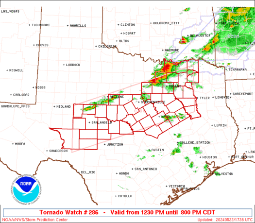
SPC Severe Thunderstorm Watch 289

WW 289 SEVERE TSTM TN 222045Z – 230300Z
WW 0289 Image

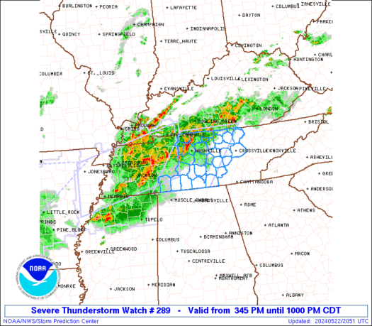
 URGENT - IMMEDIATE BROADCAST REQUESTED
Severe Thunderstorm Watch Number 289
NWS Storm Prediction Center Norman OK
345 PM CDT Wed May 22 2024 The NWS Storm Prediction Center has issued a * Severe Thunderstorm Watch for portions of Western and Middle Tennessee * Effective this Wednesday afternoon and evening from 345 PM until 1000 PM CDT. * Primary threats include... Scattered damaging wind gusts to 70 mph possible Scattered large hail events to 1.5 inches in diameter possible SUMMARY...A bowing complex of thunderstorms will move east across
the watch area the remainder of this afternoon and evening, posing a
risk for damaging wind gusts and large hail. The severe thunderstorm watch area is approximately along and 60
statute miles east and west of a line from 85 miles south southwest
of Nashville TN to 60 miles northeast of Nashville TN. For a
complete depiction of the watch see the associated watch outline
update (WOUS64 KWNS WOU9). PRECAUTIONARY/PREPAREDNESS ACTIONS... REMEMBER...A Severe Thunderstorm Watch means conditions are
favorable for severe thunderstorms in and close to the watch area.
Persons in these areas should be on the lookout for threatening
weather conditions and listen for later statements and possible
warnings. Severe thunderstorms can and occasionally do produce
tornadoes. && OTHER WATCH INFORMATION...CONTINUE...WW 284...WW 285...WW
286...WW 287...WW 288... AVIATION...A few severe thunderstorms with hail surface and aloft to
1.5 inches. Extreme turbulence and surface wind gusts to 60 knots. A
few cumulonimbi with maximum tops to 500. Mean storm motion vector
26030. ...Hart 

Read more

SPC Severe Thunderstorm Watch 288

WW 288 SEVERE TSTM MD NY PA VA WV LO CW 221900Z – 230000Z
WW 0288 Image

 URGENT - IMMEDIATE BROADCAST REQUESTED
Severe Thunderstorm Watch Number 288
NWS Storm Prediction Center Norman OK
300 PM EDT Wed May 22 2024 The NWS Storm Prediction Center has issued a * Severe Thunderstorm Watch for portions of Central Maryland Central New York Central Pennsylvania Northern Virginia Eastern Panhandle of West Virginia Lake Ontario Coastal Waters * Effective this Wednesday afternoon and evening from 300 PM until 800 PM EDT. * Primary threats include... Scattered damaging wind gusts to 65 mph possible Isolated large hail events to 1.5 inches in diameter possible SUMMARY...Scattered afternoon thunderstorms across the watch area
will pose a risk of locally damaging wind gusts and hail. The severe thunderstorm watch area is approximately along and 60
statute miles east and west of a line from 15 miles west northwest
of Watertown NY to 60 miles west southwest of Washington DC. For a
complete depiction of the watch see the associated watch outline
update (WOUS64 KWNS WOU8). PRECAUTIONARY/PREPAREDNESS ACTIONS... REMEMBER...A Severe Thunderstorm Watch means conditions are
favorable for severe thunderstorms in and close to the watch area.
Persons in these areas should be on the lookout for threatening
weather conditions and listen for later statements and possible
warnings. Severe thunderstorms can and occasionally do produce
tornadoes. && OTHER WATCH INFORMATION...CONTINUE...WW 284...WW 285...WW
286...WW 287... AVIATION...A few severe thunderstorms with hail surface and aloft to
1.5 inches. Extreme turbulence and surface wind gusts to 55 knots. A
few cumulonimbi with maximum tops to 500. Mean storm motion vector
27025. ...Hart 

Read more

SPC Severe Thunderstorm Watch 287

WW 287 SEVERE TSTM TX 221740Z – 230100Z
WW 0287 Image

 URGENT - IMMEDIATE BROADCAST REQUESTED
Severe Thunderstorm Watch Number 287
NWS Storm Prediction Center Norman OK
1240 PM CDT Wed May 22 2024 The NWS Storm Prediction Center has issued a * Severe Thunderstorm Watch for portions of Northwest Texas * Effective this Wednesday afternoon and evening from 1240 PM until 800 PM CDT. * Primary threats include... Scattered large hail and isolated very large hail events to 3 inches in diameter likely Scattered damaging wind gusts to 70 mph possible A tornado or two possible SUMMARY...Thunderstorms that form over north-central Texas this
afternoon could spread into the watch area, posing a risk of very
large hail and damaging winds. The severe thunderstorm watch area is approximately along and 55
statute miles north and south of a line from 55 miles west of
Abilene TX to 30 miles south of Ardmore OK. For a complete depiction
of the watch see the associated watch outline update (WOUS64 KWNS
WOU7). PRECAUTIONARY/PREPAREDNESS ACTIONS... REMEMBER...A Severe Thunderstorm Watch means conditions are
favorable for severe thunderstorms in and close to the watch area.
Persons in these areas should be on the lookout for threatening
weather conditions and listen for later statements and possible
warnings. Severe thunderstorms can and occasionally do produce
tornadoes. && OTHER WATCH INFORMATION...CONTINUE...WW 284...WW 285...WW 286... AVIATION...A few severe thunderstorms with hail surface and aloft to
3 inches. Extreme turbulence and surface wind gusts to 60 knots. A
few cumulonimbi with maximum tops to 500. Mean storm motion vector
25030. ...Hart 

Read more