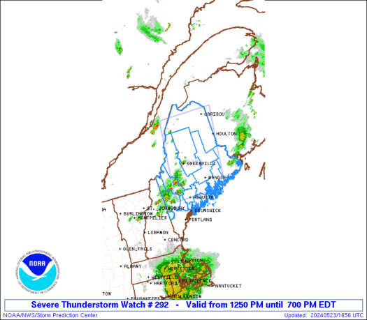
SPC Severe Thunderstorm Watch 293
WW 293 SEVERE TSTM KY TN VA 231745Z – 240000Z 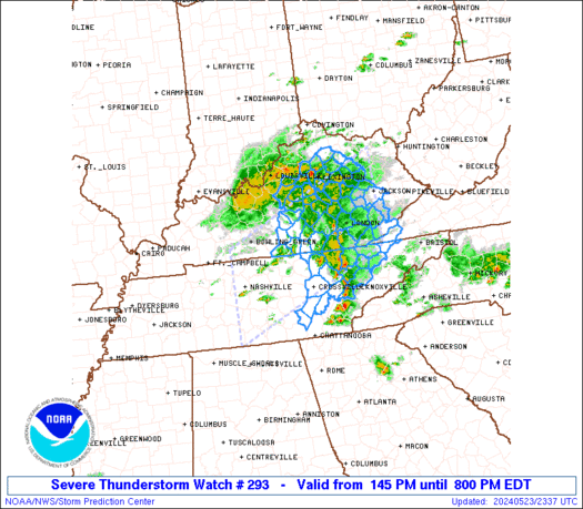
 URGENT - IMMEDIATE BROADCAST REQUESTED
Severe Thunderstorm Watch Number 293
NWS Storm Prediction Center Norman OK
145 PM EDT Thu May 23 2024 The NWS Storm Prediction Center has issued a * Severe Thunderstorm Watch for portions of Central and Eastern Kentucky Middle and East Tennessee Extreme Southwest Virginia * Effective this Thursday afternoon and evening from 145 PM until 800 PM EDT. * Primary threats include... Scattered damaging wind gusts to 65 mph possible Scattered large hail events to 1.5 inches in diameter possible SUMMARY...Thunderstorms are increasing across parts of central
Kentucky and middle Tennessee. These storms will spread eastward
across the watch area, with an occasional risk of damaging wind
gusts and hail. The severe thunderstorm watch area is approximately along and 65
statute miles north and south of a line from 20 miles southwest of
Nashville TN to 5 miles east southeast of Jackson KY. For a complete
depiction of the watch see the associated watch outline update
(WOUS64 KWNS WOU3). PRECAUTIONARY/PREPAREDNESS ACTIONS... REMEMBER...A Severe Thunderstorm Watch means conditions are
favorable for severe thunderstorms in and close to the watch area.
Persons in these areas should be on the lookout for threatening
weather conditions and listen for later statements and possible
warnings. Severe thunderstorms can and occasionally do produce
tornadoes. && OTHER WATCH INFORMATION...CONTINUE...WW 292... AVIATION...A few severe thunderstorms with hail surface and aloft to
1.5 inches. Extreme turbulence and surface wind gusts to 55 knots. A
few cumulonimbi with maximum tops to 500. Mean storm motion vector
25025. ...Hart