WW 297 SEVERE TSTM IA KS NE SD 240145Z – 240900Z
URGENT - IMMEDIATE BROADCAST REQUESTED
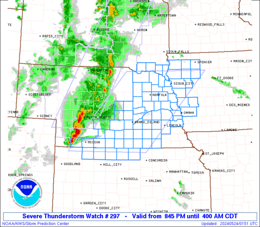
Severe Thunderstorm Watch Number 297
NWS Storm Prediction Center Norman OK
845 PM CDT Thu May 23 2024 The NWS Storm Prediction Center has issued a * Severe Thunderstorm Watch for portions of Western Iowa Extreme northern Kansas Central and eastern Nebraska Extreme southeast South Dakota * Effective this Thursday night and Friday morning from 845 PM until 400 AM CDT. * Primary threats include... Widespread damaging winds and isolated significant gusts to 85 mph likely Scattered large hail and isolated very large hail events to 2.5 inches in diameter possible A tornado or two possible SUMMARY...An intense storm cluster with embedded supercells in
central Nebraska is expected to grow upscale into a larger bowing
line overnight, with an accompanying threat for swaths of severe
wind (60-85 mph). The initial supercells could produce isolated
very large hail up to 2-2.5 inches in diameter, and a tornado or two
will be possible with embedded circulations. The severe thunderstorm watch area is approximately along and 100
statute miles east and west of a line from 35 miles north northwest
of Sioux City IA to 60 miles east southeast of Mccook NE. For a
complete depiction of the watch see the associated watch outline
update (WOUS64 KWNS WOU7). PRECAUTIONARY/PREPAREDNESS ACTIONS... REMEMBER...A Severe Thunderstorm Watch means conditions are
favorable for severe thunderstorms in and close to the watch area.
Persons in these areas should be on the lookout for threatening
weather conditions and listen for later statements and possible
warnings. Severe thunderstorms can and occasionally do produce
tornadoes. && OTHER WATCH INFORMATION...CONTINUE...WW 294...WW 295...WW 296... AVIATION...A few severe thunderstorms with hail surface and aloft to
2.5 inches. Extreme turbulence and surface wind gusts to 75 knots. A
few cumulonimbi with maximum tops to 550. Mean storm motion vector
25040. ...Thompson
Read more