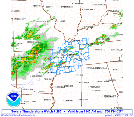
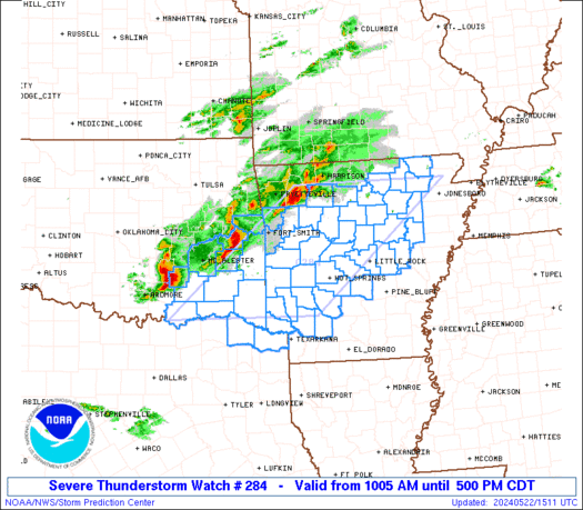
SPC Tornado Watch 286

WW 286 TORNADO TX 221730Z – 230100Z
WW 0286 Image

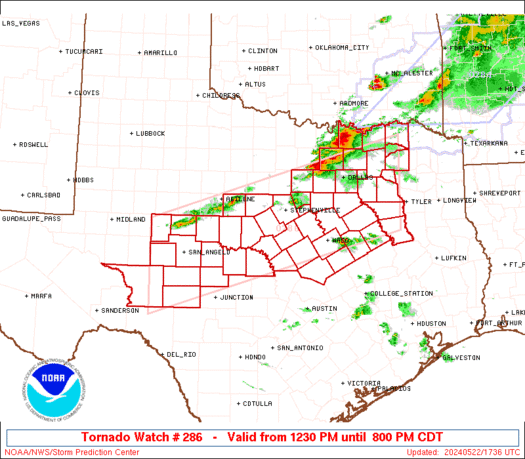
 URGENT - IMMEDIATE BROADCAST REQUESTED
Tornado Watch Number 286
NWS Storm Prediction Center Norman OK
1230 PM CDT Wed May 22 2024 The NWS Storm Prediction Center has issued a * Tornado Watch for portions of Northern and Central Texas * Effective this Wednesday afternoon and evening from 1230 PM until 800 PM CDT. * Primary threats include... A couple tornadoes possible Scattered large hail and isolated very large hail events to 4 inches in diameter likely Scattered damaging winds likely with isolated significant gusts to 80 mph possible SUMMARY...Thunderstorms will rapidly intensify this afternoon in a
very moist and unstable air mass. Very large hail and damaging
winds are the main threat, although a few tornadoes are also
expected. The tornado watch area is approximately along and 65 statute miles
north and south of a line from 50 miles west southwest of San Angelo
TX to 70 miles northeast of Corsicana TX. For a complete depiction
of the watch see the associated watch outline update (WOUS64 KWNS
WOU6). PRECAUTIONARY/PREPAREDNESS ACTIONS... REMEMBER...A Tornado Watch means conditions are favorable for
tornadoes and severe thunderstorms in and close to the watch
area. Persons in these areas should be on the lookout for
threatening weather conditions and listen for later statements
and possible warnings. && OTHER WATCH INFORMATION...CONTINUE...WW 284...WW 285... AVIATION...Tornadoes and a few severe thunderstorms with hail
surface and aloft to 4 inches. Extreme turbulence and surface wind
gusts to 70 knots. A few cumulonimbi with maximum tops to 500. Mean
storm motion vector 28030. ...Hart 

Read more

SPC Severe Thunderstorm Watch 285

WW 285 SEVERE TSTM AR KY MO MS TN 221645Z – 230000Z
WW 0285 Image

 URGENT - IMMEDIATE BROADCAST REQUESTED
Severe Thunderstorm Watch Number 285
NWS Storm Prediction Center Norman OK
1145 AM CDT Wed May 22 2024 The NWS Storm Prediction Center has issued a * Severe Thunderstorm Watch for portions of Northeast Arkansas Southwest Kentucky Southeast Missouri Northern Mississippi Western Tennessee * Effective this Wednesday morning and evening from 1145 AM until 700 PM CDT. * Primary threats include... Scattered damaging wind gusts to 70 mph likely Scattered large hail and isolated very large hail events to 2 inches in diameter possible SUMMARY...Thunderstorms that are forming over eastern Arkansas will
intensify this afternoon and spread eastward across the watch area. Locally damaging wind gusts and hail are possible with the stronger
cells. The severe thunderstorm watch area is approximately along and 55
statute miles north and south of a line from 40 miles south
southwest of Jonesboro AR to 30 miles south southeast of Clarksville
TN. For a complete depiction of the watch see the associated watch
outline update (WOUS64 KWNS WOU5). PRECAUTIONARY/PREPAREDNESS ACTIONS... REMEMBER...A Severe Thunderstorm Watch means conditions are
favorable for severe thunderstorms in and close to the watch area.
Persons in these areas should be on the lookout for threatening
weather conditions and listen for later statements and possible
warnings. Severe thunderstorms can and occasionally do produce
tornadoes. && OTHER WATCH INFORMATION...CONTINUE...WW 284... AVIATION...A few severe thunderstorms with hail surface and aloft to
2 inches. Extreme turbulence and surface wind gusts to 60 knots. A
few cumulonimbi with maximum tops to 500. Mean storm motion vector
26030. ...Hart 

Read more

🔴 LIVE TEXAS CHASE – Tornado Watch – Large Hail, Extreme Winds – Enhanced Risk Coverage {D-C-J-A}

🔴 LIVE TEXAS CHASE – Tornado Watch – Large Hail, Extreme Winds – Enhanced Risk Coverage {D-C-J-A}

Join this channel to get access to perks: https://www.youtube.com/channel/UCNPvoDpoOWevcdTHr8GyTyA/join Our chasers Chelsea, Adam and Jason are chasing severe storms capable of large hail and a few tornadoes in Central to North Texas and the DFW Metroplex (May 22, 2024) #IRL #Tornado #StormChasers NOT for rebroadcast or embedding. Email us at contact@texasstormchasers.com for licensing inquiries. Check […]

SPC Severe Thunderstorm Watch 284

WW 284 SEVERE TSTM AR OK TX 221505Z – 222200Z
WW 0284 Image

 URGENT - IMMEDIATE BROADCAST REQUESTED
Severe Thunderstorm Watch Number 284
NWS Storm Prediction Center Norman OK
1005 AM CDT Wed May 22 2024 The NWS Storm Prediction Center has issued a * Severe Thunderstorm Watch for portions of Central and Western Arkansas Southeast Oklahoma Northeast Texas * Effective this Wednesday morning and afternoon from 1005 AM until 500 PM CDT. * Primary threats include... Scattered large hail and isolated very large hail events to 2.5 inches in diameter likely Scattered damaging winds likely with isolated significant gusts to 75 mph possible A tornado or two possible SUMMARY...Intensifying thunderstorms over eastern Oklahoma will
track across Arkansas through the afternoon, posing a risk of large
hail and damaging winds. The severe thunderstorm watch area is approximately along and 90
statute miles east and west of a line from 35 miles west southwest
of De Queen AR to 40 miles northwest of Batesville AR. For a
complete depiction of the watch see the associated watch outline
update (WOUS64 KWNS WOU4). PRECAUTIONARY/PREPAREDNESS ACTIONS... REMEMBER...A Severe Thunderstorm Watch means conditions are
favorable for severe thunderstorms in and close to the watch area.
Persons in these areas should be on the lookout for threatening
weather conditions and listen for later statements and possible
warnings. Severe thunderstorms can and occasionally do produce
tornadoes. && AVIATION...A few severe thunderstorms with hail surface and aloft to
2.5 inches. Extreme turbulence and surface wind gusts to 65 knots. A
few cumulonimbi with maximum tops to 500. Mean storm motion vector
27030. ...Hart 

Read more

Get Ready, Texas: Big Storms On The Way!

Get Ready, Texas: Big Storms On The Way!

Severe thunderstorms will return to Texas over the next several days. Today looks particularly active, with multiple rounds of storms expected later this morning and late tonight. The most intense storms may produce very large to giant hail up to the size of softballs, localized hurricane-force wind gusts over 75 to 85 MPH, flooding rainfall, […]