SPC – No watches are valid as of Sun May 19 03:02:01 UTC 2024
No watches are valid as of Sun May 19 03:02:01 UTC 2024.
24/7 Tornado Newsfeed
No watches are valid as of Sun May 19 03:02:01 UTC 2024.

Strong to severe thunderstorms in North Carolina produced a quick 3-4" of rainfall across communities north of Charlotte on Saturday. Trees and tents were reported to be toppled over in the area of Wilkesboro, and flooding was seen around the speedway.

A look at the games to watch during the 2024 NFL regular season. The 18-week, 272-game schedule faces a variety of weather extremes from wind and rain to hurricanes and extreme heat.
WW 257 SEVERE TSTM MI MN WI LS 182030Z – 190300Z 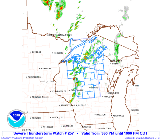
 URGENT - IMMEDIATE BROADCAST REQUESTED
Severe Thunderstorm Watch Number 257
NWS Storm Prediction Center Norman OK
330 PM CDT Sat May 18 2024 The NWS Storm Prediction Center has issued a * Severe Thunderstorm Watch for portions of Western Upper Michigan Minnesota Arrowhead Central and Northern Wisconsin Lake Superior * Effective this Saturday afternoon and evening from 330 PM until 1000 PM CDT. * Primary threats include... Scattered damaging wind gusts to 70 mph possible Scattered large hail events to 1.5 inches in diameter possible SUMMARY...Thunderstorms are developing along a cold front over
western Wisconsin and northeast Minnesota. These storms will track
eastward through the early evening, posing a risk of hail and
damaging winds. The severe thunderstorm watch area is approximately along and 50
statute miles east and west of a line from 30 miles north northeast
of Grand Marais MN to 35 miles south of Mosinee WI. For a complete
depiction of the watch see the associated watch outline update
(WOUS64 KWNS WOU7). PRECAUTIONARY/PREPAREDNESS ACTIONS... REMEMBER...A Severe Thunderstorm Watch means conditions are
favorable for severe thunderstorms in and close to the watch area.
Persons in these areas should be on the lookout for threatening
weather conditions and listen for later statements and possible
warnings. Severe thunderstorms can and occasionally do produce
tornadoes. && AVIATION...A few severe thunderstorms with hail surface and aloft to
1.5 inches. Extreme turbulence and surface wind gusts to 60 knots. A
few cumulonimbi with maximum tops to 500. Mean storm motion vector
26030. ...Hart

Cleaning up after storm damage during natural disaster recovery can pose significant health risks, including a danger that doesn't get much attention.

Wildlife officials said the bear had gotten in the trash and found food. When the rangers arrived, the bear was already in a tree.

The owners of a popular Houston area Cajun restaurant are picking up the pieces after Thursdayâs derecho blasted the region with winds estimated at 90-100 mph.

Two beautifully preserved historic homes on the Gettysburg battlefield will soon be open for overnight stays, offering visitors a unique opportunity to immerse themselves in the area's rich history.

The Mount St. Helens' eruption in Washington on May 18, 1980 is the worst volcanic eruption in U.S. history, killing 57 people and spewing 520 million tons of ash across the U.S., causing complete darkness in Spokane.