SPC Tornado Watch 252

WW 252 TORNADO AL MS CW 170350Z – 170800Z
WW 0252 Image

 URGENT - IMMEDIATE BROADCAST REQUESTED
Tornado Watch Number 252
NWS Storm Prediction Center Norman OK
1050 PM CDT Thu May 16 2024 The NWS Storm Prediction Center has issued a * Tornado Watch for portions of Southern Alabama Southern Mississippi Coastal Waters * Effective this Thursday night and Friday morning from 1050 PM until 300 AM CDT. * Primary threats include... A couple tornadoes possible Isolated damaging wind gusts to 70 mph possible SUMMARY...A severe squall line over southeast Louisiana will
continue east and move into the Watch area tonight. In addition to
the risk for a couple of tornadoes, severe gusts (60-70 mph) capable
of wind damage may accompany the more intense thunderstorm cores and
outflow surges in the squall line. The tornado watch area is approximately along and 30 statute miles
north and south of a line from 35 miles west of Gulfport MS to 30
miles southeast of Mobile AL. For a complete depiction of the watch
see the associated watch outline update (WOUS64 KWNS WOU2). PRECAUTIONARY/PREPAREDNESS ACTIONS... REMEMBER...A Tornado Watch means conditions are favorable for
tornadoes and severe thunderstorms in and close to the watch
area. Persons in these areas should be on the lookout for
threatening weather conditions and listen for later statements
and possible warnings. && OTHER WATCH INFORMATION...CONTINUE...WW 250...WW 251... AVIATION...Tornadoes and a few severe thunderstorms with hail
surface and aloft to 1.5 inches. Extreme turbulence and surface wind
gusts to 60 knots. A few cumulonimbi with maximum tops to 500. Mean
storm motion vector 27035. ...Smith 

Read more

SPC Tornado Watch 251

WW 251 TORNADO LA CW 170055Z – 170800Z
WW 0251 Image

 URGENT - IMMEDIATE BROADCAST REQUESTED
Tornado Watch Number 251
NWS Storm Prediction Center Norman OK
755 PM CDT Thu May 16 2024 The NWS Storm Prediction Center has issued a * Tornado Watch for portions of Southeast Louisiana Coastal Waters * Effective this Thursday night and Friday morning from 755 PM until 300 AM CDT. * Primary threats include... A couple tornadoes possible Scattered damaging winds and isolated significant gusts to 75 mph possible Isolated large hail events to 1.5 inches in diameter possible SUMMARY...A broken squall line will move east into southeast
Louisiana this evening and progress east across the Watch area
tonight. In addition to the risk for a couple of tornadoes, severe
gusts (60-75 mph) capable of wind damage may accompany the more
intense portions of the squall line. The tornado watch area is approximately along and 65 statute miles
north and south of a line from 5 miles north of Lafayette LA to 35
miles east of Boothville LA. For a complete depiction of the watch
see the associated watch outline update (WOUS64 KWNS WOU1). PRECAUTIONARY/PREPAREDNESS ACTIONS... REMEMBER...A Tornado Watch means conditions are favorable for
tornadoes and severe thunderstorms in and close to the watch
area. Persons in these areas should be on the lookout for
threatening weather conditions and listen for later statements
and possible warnings. && OTHER WATCH INFORMATION...CONTINUE...WW 249...WW 250... AVIATION...Tornadoes and a few severe thunderstorms with hail
surface and aloft to 1.5 inches. Extreme turbulence and surface wind
gusts to 65 knots. A few cumulonimbi with maximum tops to 500. Mean
storm motion vector 27035. ...Smith 

Read more

SPC Severe Thunderstorm Watch 250

WW 250 SEVERE TSTM NM TX 162000Z – 170400Z
WW 0250 Image

 URGENT - IMMEDIATE BROADCAST REQUESTED
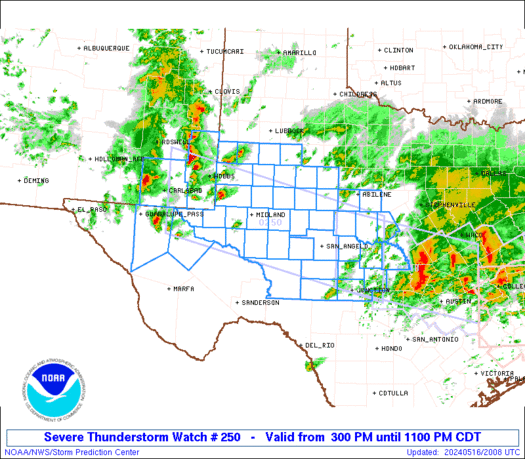
Severe Thunderstorm Watch Number 250
NWS Storm Prediction Center Norman OK
300 PM CDT Thu May 16 2024 The NWS Storm Prediction Center has issued a * Severe Thunderstorm Watch for portions of Southeast New Mexico West Texas into the Edwards Plateau * Effective this Thursday afternoon and evening from 300 PM until 1100 PM CDT. * Primary threats include... Scattered large hail and isolated very large hail events to 2 inches in diameter possible Scattered damaging wind gusts to 70 mph possible SUMMARY...Thunderstorms will increase in coverage and intensity
through the afternoon/evening while spreading from southeast New
Mexico into west Texas and the Edwards Plateau. The main threats
will be large hail up to 2 inches in diameter with the more discrete
supercells, while severe outflow winds of 60-70 mph will be possible
as storms grow upscale into one or more line segments. The severe thunderstorm watch area is approximately along and 60
statute miles north and south of a line from 60 miles west southwest
of Hobbs NM to 60 miles northeast of Junction TX. For a complete
depiction of the watch see the associated watch outline update
(WOUS64 KWNS WOU0). PRECAUTIONARY/PREPAREDNESS ACTIONS... REMEMBER...A Severe Thunderstorm Watch means conditions are
favorable for severe thunderstorms in and close to the watch area.
Persons in these areas should be on the lookout for threatening
weather conditions and listen for later statements and possible
warnings. Severe thunderstorms can and occasionally do produce
tornadoes. && OTHER WATCH INFORMATION...CONTINUE...WW 248...WW 249... AVIATION...A few severe thunderstorms with hail surface and aloft to
2 inches. Extreme turbulence and surface wind gusts to 60 knots. A
few cumulonimbi with maximum tops to 500. Mean storm motion vector
29025. ...Thompson 

Read more