Day: May 9, 2024
SPC Severe Thunderstorm Watch 227
WW 227 SEVERE TSTM LA MS 100455Z – 101000Z 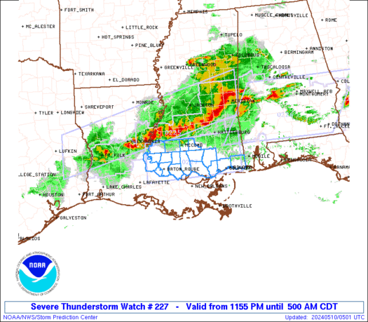
 URGENT - IMMEDIATE BROADCAST REQUESTED
Severe Thunderstorm Watch Number 227
NWS Storm Prediction Center Norman OK
1155 PM CDT Thu May 9 2024 The NWS Storm Prediction Center has issued a * Severe Thunderstorm Watch for portions of Southeast Louisiana Southern Mississippi * Effective this Thursday night and Friday morning from 1155 PM until 500 AM CDT. * Primary threats include... Widespread damaging winds and isolated significant gusts to 80 mph likely Scattered large hail and isolated very large hail events to 2 inches in diameter possible A tornado or two possible SUMMARY...Intense thunderstorms over central Louisiana will track
east-southeastward overnight across the watch area. Damaging winds
will be possible with these storms. The severe thunderstorm watch area is approximately along and 40
statute miles north and south of a line from 80 miles west southwest
of Mc Comb MS to 45 miles northeast of Gulfport MS. For a complete
depiction of the watch see the associated watch outline update
(WOUS64 KWNS WOU7). PRECAUTIONARY/PREPAREDNESS ACTIONS... REMEMBER...A Severe Thunderstorm Watch means conditions are
favorable for severe thunderstorms in and close to the watch area.
Persons in these areas should be on the lookout for threatening
weather conditions and listen for later statements and possible
warnings. Severe thunderstorms can and occasionally do produce
tornadoes. && OTHER WATCH INFORMATION...CONTINUE...WW 224...WW 225...WW 226... AVIATION...A few severe thunderstorms with hail surface and aloft to
2 inches. Extreme turbulence and surface wind gusts to 70 knots. A
few cumulonimbi with maximum tops to 500. Mean storm motion vector
28035. ...Hart
A look at how active the hurricane season could be in the eastern Pacific

Mexicoâs national weather service expects an average to slightly above-average tropical cyclone season in the eastern Pacific. Between May 15 and November 30, 15-18 named storms are expected to form, with 7-9 hurricanes and 3-4 major hurricanes. The first storm system that has sustained winds of at least 39 mph will earn the name of Aletta.
SPC Severe Thunderstorm Watch 226
WW 226 SEVERE TSTM AL GA MS 100340Z – 101000Z 
 URGENT - IMMEDIATE BROADCAST REQUESTED
Severe Thunderstorm Watch Number 226
NWS Storm Prediction Center Norman OK
1040 PM CDT Thu May 9 2024 The NWS Storm Prediction Center has issued a * Severe Thunderstorm Watch for portions of Southern Alabama Southwest Georgia Southern Mississippi * Effective this Thursday night and Friday morning from 1040 PM until 500 AM CDT. * Primary threats include... Widespread damaging winds and isolated significant gusts to 80 mph likely Scattered large hail likely with isolated very large hail events to 2 inches in diameter possible A tornado or two possible SUMMARY...Multiple clusters of fast-moving thunderstorms are
expected to affect the watch area tonight. Damaging winds and hail
are expected with the most intense storms. The severe thunderstorm watch area is approximately along and 110
statute miles east and west of a line from 25 miles south southwest
of Evergreen AL to 40 miles north northeast of Montgomery AL. For a
complete depiction of the watch see the associated watch outline
update (WOUS64 KWNS WOU6). PRECAUTIONARY/PREPAREDNESS ACTIONS... REMEMBER...A Severe Thunderstorm Watch means conditions are
favorable for severe thunderstorms in and close to the watch area.
Persons in these areas should be on the lookout for threatening
weather conditions and listen for later statements and possible
warnings. Severe thunderstorms can and occasionally do produce
tornadoes. && OTHER WATCH INFORMATION...CONTINUE...WW 223...WW 224...WW 225... AVIATION...A few severe thunderstorms with hail surface and aloft to
2 inches. Extreme turbulence and surface wind gusts to 70 knots. A
few cumulonimbi with maximum tops to 500. Mean storm motion vector
27035. ...Hart
SPC Severe Thunderstorm Watch 225
WW 225 SEVERE TSTM LA MS TX 100115Z – 100800Z 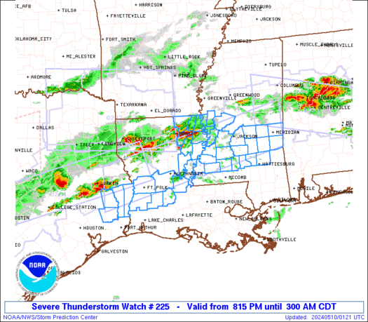
 URGENT - IMMEDIATE BROADCAST REQUESTED
Severe Thunderstorm Watch Number 225
NWS Storm Prediction Center Norman OK
815 PM CDT Thu May 9 2024 The NWS Storm Prediction Center has issued a * Severe Thunderstorm Watch for portions of Central Louisiana Central Mississippi Southeast Texas * Effective this Thursday night and Friday morning from 815 PM until 300 AM CDT. * Primary threats include... Scattered damaging winds and isolated significant gusts to 75 mph likely Scattered large hail and isolated very large hail events to 2 inches in diameter likely A tornado or two possible SUMMARY...Thunderstorms over East Texas and northern Louisiana will
develop eastward through the evening across the watch area, large
hail is possible early, with an increasing risk of damaging winds as
storms organize into lines. The severe thunderstorm watch area is approximately along and 45
statute miles north and south of a line from 80 miles west of Fort
Polk LA to 25 miles northeast of Meridian MS. For a complete
depiction of the watch see the associated watch outline update
(WOUS64 KWNS WOU5). PRECAUTIONARY/PREPAREDNESS ACTIONS... REMEMBER...A Severe Thunderstorm Watch means conditions are
favorable for severe thunderstorms in and close to the watch area.
Persons in these areas should be on the lookout for threatening
weather conditions and listen for later statements and possible
warnings. Severe thunderstorms can and occasionally do produce
tornadoes. && OTHER WATCH INFORMATION...CONTINUE...WW 221...WW 222...WW
223...WW 224... AVIATION...A few severe thunderstorms with hail surface and aloft to
2 inches. Extreme turbulence and surface wind gusts to 65 knots. A
few cumulonimbi with maximum tops to 500. Mean storm motion vector
27035. ...Hart
See it: Beer truck overturns in California dumping cases in the snow

While hundreds of cases of beer on ice may sound like a dream, it was a nightmare for one truck driver who lost the load on an icy mountain interstate Monday.
See what communities looked like before and after May’s tornado outbreak from aerial imagery

Geospatial Insurance Consortium (GIC) released imagery of neighborhoods in Barnsdall, Oklahoma, and Portage, Michigan, after devasting tornadoes. The Storm Prediction Center has received preliminary reports of 123 tornadoes impacting the U.S. through early May.
