🔴 May 8, 2024 LIVE Texas Severe Weather & Tornado Coverage

🔴 May 8, 2024 LIVE Texas Severe Weather & Tornado Coverage

Join this channel to get access to perks: https://www.youtube.com/channel/UCoIfgmxArIATc2EpHD3W9EA/join Check out our current LIVE STREAM: https://texasweather.video/ Our FREE WEATHER APP: https://texasweather.app/ Our WEBSITE/RADAR: https://www.texasstormchasers.com Our SOCIAL PLATFORMS: https://linktr.ee/texasstormchasers Donations – Paypal@texasstormchasers.com *Enable 4K 60FPS when possible for best viewing results* #texas #texasweather #weather #abilene #alpine #amarillo #austin #beaumont #beeville #bigbend #brownsville #brownwood #canadian #childress #collegestation […]

SPC Severe Thunderstorm Watch 203

WW 203 SEVERE TSTM NC SC TN 081405Z – 082000Z
WW 0203 Image

 URGENT - IMMEDIATE BROADCAST REQUESTED
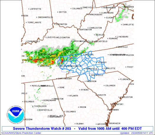
Severe Thunderstorm Watch Number 203
NWS Storm Prediction Center Norman OK
1005 AM EDT Wed May 8 2024 The NWS Storm Prediction Center has issued a * Severe Thunderstorm Watch for portions of Western North Carolina Upstate South Carolina Eastern Tennessee * Effective this Wednesday morning and afternoon from 1005 AM until 400 PM EDT. * Primary threats include... Scattered damaging wind gusts to 70 mph likely Scattered large hail events to 1.5 inches in diameter likely SUMMARY...Clusters of storms, with both bowing and embedded
supercell characteristics, will likely continue into the afternoon
while spreading east-southeastward across eastern Tennessee into
western North Carolina and the northern part of upstate South
Carolina. Scattered damaging winds of 60-70 mph and large hail of
1-1.5 inches in diameter can be expected. The severe thunderstorm watch area is approximately along and 40
statute miles north and south of a line from 40 miles west northwest
of Knoxville TN to 10 miles north of Charlotte NC. For a complete
depiction of the watch see the associated watch outline update
(WOUS64 KWNS WOU3). PRECAUTIONARY/PREPAREDNESS ACTIONS... REMEMBER...A Severe Thunderstorm Watch means conditions are
favorable for severe thunderstorms in and close to the watch area.
Persons in these areas should be on the lookout for threatening
weather conditions and listen for later statements and possible
warnings. Severe thunderstorms can and occasionally do produce
tornadoes. && OTHER WATCH INFORMATION...CONTINUE...WW 202... AVIATION...A few severe thunderstorms with hail surface and aloft to
1.5 inches. Extreme turbulence and surface wind gusts to 60 knots. A
few cumulonimbi with maximum tops to 500. Mean storm motion vector
24035. ...Thompson 

Read more

SPC Severe Thunderstorm Watch 202

WW 202 SEVERE TSTM KS MO 081150Z – 081900Z
WW 0202 Image

 URGENT - IMMEDIATE BROADCAST REQUESTED
Severe Thunderstorm Watch Number 202
NWS Storm Prediction Center Norman OK
650 AM CDT Wed May 8 2024 The NWS Storm Prediction Center has issued a * Severe Thunderstorm Watch for portions of Extreme eastern Kansas Western and central Missouri * Effective this Wednesday morning and afternoon from 650 AM until 200 PM CDT. * Primary threats include... Scattered large hail and isolated very large hail events to 3 inches in diameter likely Scattered damaging wind gusts to 70 mph possible SUMMARY...Initially elevated thunderstorms erupting near the KS/MO
line will pose a threat for large to very large hail through midday
as individual cells move northeastward to eastward. A portion of
this activity may organize into an eastward- to
southeastward-moving, upscale-growing cluster with increasing
damaging-wind potential. The severe thunderstorm watch area is approximately along and 75
statute miles north and south of a line from 15 miles west southwest
of Olathe KS to Vichy MO. For a complete depiction of the watch see
the associated watch outline update (WOUS64 KWNS WOU2). PRECAUTIONARY/PREPAREDNESS ACTIONS... REMEMBER...A Severe Thunderstorm Watch means conditions are
favorable for severe thunderstorms in and close to the watch area.
Persons in these areas should be on the lookout for threatening
weather conditions and listen for later statements and possible
warnings. Severe thunderstorms can and occasionally do produce
tornadoes. && AVIATION...A few severe thunderstorms with hail surface and aloft to
3 inches. Extreme turbulence and surface wind gusts to 60 knots. A
few cumulonimbi with maximum tops to 550. Mean storm motion vector
27030. ...Edwards 

Read more

Texas: Big Hail And Damaging Winds To Hit As Storms Return!

Texas: Big Hail And Damaging Winds To Hit As Storms Return!

Scattered thunderstorm chances return to Texas over the coming days. With storms in May usually come big hail, strong winds, and enough lightning to make you bring out the sunglasses at night. While some will be dealing with nasty storms, some will be stuck with heat and humidity… until a cold front arrives by week’s […]