SPC Tornado Watch 199

WW 199 TORNADO KY OH WV 080115Z – 080800Z
WW 0199 Image

 URGENT - IMMEDIATE BROADCAST REQUESTED
Tornado Watch Number 199
NWS Storm Prediction Center Norman OK
915 PM EDT Tue May 7 2024 The NWS Storm Prediction Center has issued a * Tornado Watch for portions of Northeast Kentucky Eastern Ohio Northwest West Virginia * Effective this Tuesday night and Wednesday morning from 915 PM until 400 AM EDT. * Primary threats include... A few tornadoes likely Scattered large hail and isolated very large hail events to 2 inches in diameter possible Scattered damaging wind gusts to 70 mph possible SUMMARY...Intense thunderstorms over western Ohio will track
eastward across the watch area this evening and tonight, posing a
risk of damaging winds, hail, and a few tornadoes. The tornado watch area is approximately along and 55 statute miles
east and west of a line from 10 miles west northwest of Akron OH to
30 miles east of Huntington WV. For a complete depiction of the
watch see the associated watch outline update (WOUS64 KWNS WOU9). PRECAUTIONARY/PREPAREDNESS ACTIONS... REMEMBER...A Tornado Watch means conditions are favorable for
tornadoes and severe thunderstorms in and close to the watch
area. Persons in these areas should be on the lookout for
threatening weather conditions and listen for later statements
and possible warnings. && OTHER WATCH INFORMATION...CONTINUE...WW 196...WW 197...WW 198... AVIATION...Tornadoes and a few severe thunderstorms with hail
surface and aloft to 2 inches. Extreme turbulence and surface wind
gusts to 60 knots. A few cumulonimbi with maximum tops to 500. Mean
storm motion vector 25030. ...Hart 

Read more

SPC Tornado Watch 198

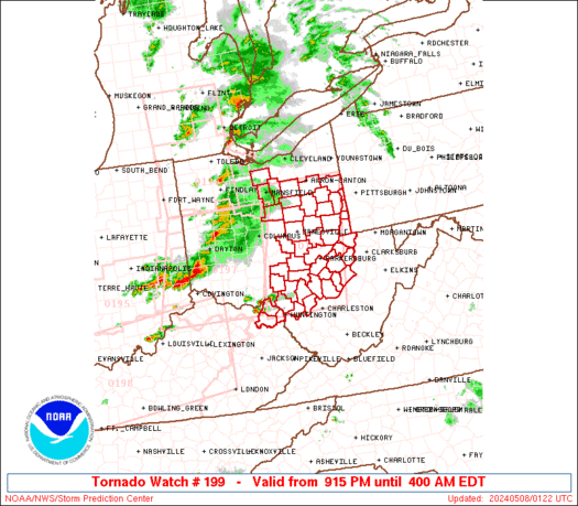
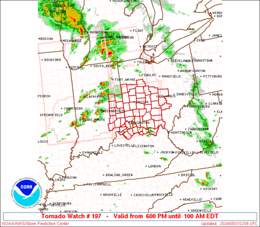
WW 198 TORNADO IL IN KY MO 080000Z – 080700Z
WW 0198 Image

 URGENT - IMMEDIATE BROADCAST REQUESTED
Tornado Watch Number 198
NWS Storm Prediction Center Norman OK
700 PM CDT Tue May 7 2024 The NWS Storm Prediction Center has issued a * Tornado Watch for portions of Southern Illinois Southern Indiana Central and Western Kentucky Southeast Missouri * Effective this Tuesday night and Wednesday morning from 700 PM until 200 AM CDT. * Primary threats include... A few tornadoes likely with a couple intense tornadoes possible Scattered large hail and isolated very large hail events to 2.5 inches in diameter likely Scattered damaging wind gusts to 70 mph likely SUMMARY...Widely scattered thunderstorms are beginning to develop
across the watch area. These storms will organize into supercells,
capable of large hail, damaging winds, and a few tornadoes through
the evening. The tornado watch area is approximately along and 65 statute miles
north and south of a line from 30 miles east of Lexington KY to 5
miles northwest of Cape Girardeau MO. For a complete depiction of
the watch see the associated watch outline update (WOUS64 KWNS
WOU8). PRECAUTIONARY/PREPAREDNESS ACTIONS... REMEMBER...A Tornado Watch means conditions are favorable for
tornadoes and severe thunderstorms in and close to the watch
area. Persons in these areas should be on the lookout for
threatening weather conditions and listen for later statements
and possible warnings. && OTHER WATCH INFORMATION...CONTINUE...WW 195...WW 196...WW 197... AVIATION...Tornadoes and a few severe thunderstorms with hail
surface and aloft to 2.5 inches. Extreme turbulence and surface wind
gusts to 60 knots. A few cumulonimbi with maximum tops to 500. Mean
storm motion vector 25030. ...Hart 

Read more

SPC Tornado Watch 197

WW 197 TORNADO IN KY OH 072200Z – 080500Z
WW 0197 Image

 URGENT - IMMEDIATE BROADCAST REQUESTED
Tornado Watch Number 197
NWS Storm Prediction Center Norman OK
600 PM EDT Tue May 7 2024 The NWS Storm Prediction Center has issued a * Tornado Watch for portions of Eastern Indiana Northern Kentucky Western Ohio * Effective this Tuesday night and Wednesday morning from 600 PM until 100 AM EDT. * Primary threats include... A few tornadoes and a couple intense tornadoes likely Scattered large hail and isolated very large hail events to 2 inches in diameter likely Scattered damaging wind gusts to 70 mph likely SUMMARY...Scattered intense thunderstorms over central Indiana will
track eastward through the evening, affecting the watch area. Large
hail, damaging winds, and a few tornadoes are possible with this
activity. The tornado watch area is approximately along and 70 statute miles
east and west of a line from 55 miles north northeast of Dayton OH
to 45 miles south of Cincinnati OH. For a complete depiction of the
watch see the associated watch outline update (WOUS64 KWNS WOU7). PRECAUTIONARY/PREPAREDNESS ACTIONS... REMEMBER...A Tornado Watch means conditions are favorable for
tornadoes and severe thunderstorms in and close to the watch
area. Persons in these areas should be on the lookout for
threatening weather conditions and listen for later statements
and possible warnings. && OTHER WATCH INFORMATION...CONTINUE...WW 195...WW 196... AVIATION...Tornadoes and a few severe thunderstorms with hail
surface and aloft to 2 inches. Extreme turbulence and surface wind
gusts to 60 knots. A few cumulonimbi with maximum tops to 500. Mean
storm motion vector 25035. ...Hart 

Read more

Texas Weather: Cool Front and Storm Chances on the Way!

Texas Weather: Cool Front and Storm Chances on the Way!

We’ve enjoyed a few days of less active weather across Texas, and hopefully, it’ll remain that way for the remainder of today. Thunderstorm chances return on Wednesday and Thursday as a cool front moves south into the state. Isolated severe thunderstorms are possible through the early evening across the Hill Country and South-Central Texas. The […]